


Ships and Vessels
Ships and Vessels介绍
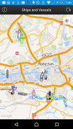
This app presents allows users to locate ships and vessels live on a map.
Just open the app, let it find your location and press the refresh button.
If any ships nearby with appropriate AIS transponders and a receiving station in our network is picking it up you should be able to see the ships on the map.
See the following ship/vessel details:
Update time
MMSI number
IMO number (Internation Maritime Organisation)
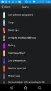
Ship Type (Passenger, cargo, pleasure, dive, military and many more)
Navigational status (under way, berthing, moored and many more)
Rate of Turn (when available)
Speed (kts)
Course
True Heading
Special Maneuvres
Latitude and Longitude
Destination port (call of port) when available
ETA (Estimated Time of Arrival) when available
Vessel Length (meters)
Vessel Width (meters)
Vessel Draught (meters)
To Bow (from AIS transponder)
To Stern (from AIS transponder)
To Port (from AIS transponder)
To Starboard (from AIS transponder)
We hope you enjoy the app please leave a good rating in order to keep us improving the app.
</div> <div jsname="WJz9Hc" style="display:none">这个应用程序呈现允许用户查找船舶和船舶生活在地图上。
只需打开应用程序,让它找到你的位置,然后按刷新按钮。
如果附近的任何附带适当的AIS应答器和我们的网络中的接收站拿起它,你应该能够看到船在地图上。
请参阅下面的船只/船只的详细信息:
更新时间
MMSI号码
IMO编号(国际海事机构)
船舶类型(客,货,休闲,潜水,军事等等)
航行状态(正在进行,停泊,停泊和许多更多)
转弯率的(如果可用)
速度(KTS)
过程
真航向
特别Maneuvres
纬度和经度
目的端口(端口调用)时可用
ETA(预计到达时间)时可用
船舶长度(米)
船宽(米)
船舶吃水(米)
低头(从AIS应答器)
斯特恩(从AIS应答器)
到端口(从AIS应答器)
向右舷(从AIS应答器)
我们希望你喜欢的应用程序,请留下良好的评价,以使我们提高了应用程序。</div> <div class="show-more-end">
Ships and Vessels - 版本2.1
(21-09-2015)Ships and Vessels - APK信息
APK版本: 2.1程序包: com.ous.trackashipShips and Vessels的最新版本


同类应用


